At sea, weather is not just a setting — it is an active, in-flux force that can determine the fate of an entire journey. Mariners don’t have time to wait for things to stabilize. They require devices that assist them in predicting, monitoring, and adjusting.
That’s where onboard meteorological equipment enters the picture. These tools enable ships to track wind, pressure, humidity, temperature, and other conditions — for safety and efficiency of operations.
Here’s a closer look at the top 8 meteorological instruments used on ships, and what they really do.
1. Barometer
Purpose: To measure atmospheric pressure
A favourite in every ship’s weather arsenal, the barometer can forecast short-term weather shifts. A sharp pressure drop? Look out for a storm brewing. Gradual increase? Sunnier skies ahead.
Most ships employ aneroid barometers, which are small and rugged for use in the marine conditions.
2. Hygrometer
Purpose: Reads humidity in the air
The hygrometer informs you about the amount of moisture in the air — something that can impact fog development, visibility, and even the functioning of onboard electronic devices.
Digital hygrometers combined with temperature sensors are commonly found on modern ships for better measurements.
3. Thermometer
Purpose: Prides itself on measuring temperature (air and occasionally sea)
No rocket science involved here — the thermometer is utilized to monitor air temperature, usually recorded with humidity to determine dew point and watch for fog conditions. Sea surface temperature might also be recorded by ships, which can be significant for route planning, particularly in polar or equatorial areas.
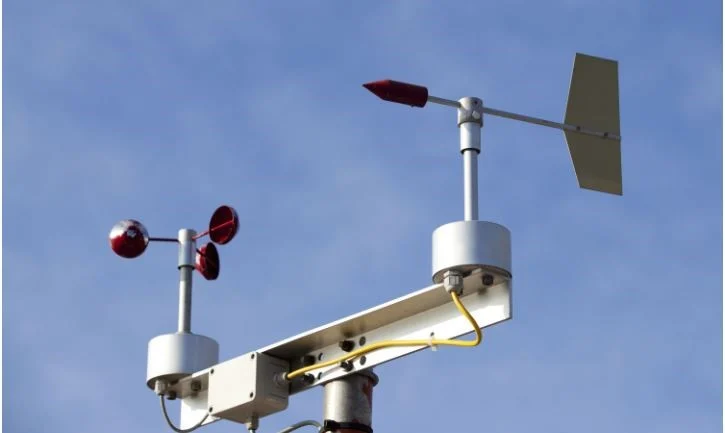
4. Anemometer
Purpose: Measures wind speed
Wind impacts everything — from ship stability, assistant
engine load, and fuel usage to everything in between. The anemometer gives instantaneous wind speed information and tends to be located on the mast or other exposed position. It functions together with wind vanes for total wind indication.
Digital anemometers currently transmit information straight to the bridge display for real-time updates.
5. Wind Vane
Purpose: Shows wind direction.Generally mounted close to the anemometer, the wind vane indicates from which direction the wind is blowing. It is important for all from manoeuvring while berthing to heavy weather navigation adjustments.
Marine versions differ from land-based vanes in being designed to accommodate continuous motion and salt spray exposure.
6.Psychrometer
Function: Measures relative humidity with two thermometers
The psychrometer has a dry bulb and a wet bulb thermometer. As air is drawn over both, the reading difference is employed to determine relative humidity. It’s particularly handy in more conventional installations or for calibrating electronic hygrometers.
Used still in weather observations transmitted to meteorological centers.
7. Marine Weather Fax (Facsimile Receiver)
Use: Receives weather charts by radio
Although slightly out-of-date, the weather fax is still useful — particularly on ships that travel to distant areas with poor internet. It gets synoptic weather charts through high-frequency radio and enables officers to evaluate large-scale weather systems.
The system provides a “big picture” view of emerging systems such as depressions or cyclones.
8. Weather Logging Software & Sensors
Purpose: Automatic weather data collection and transmission
Today’s vessels are moving towards automatic weather monitoring systems with sensors for wind, pressure, temperature, and humidity — all recorded by onboard computers.
This information is:
- Applied in navigation decisions
- Dispatched to meteorological services
- Added to global weather forecasting models.
Even some systems interface with ECDIS or voyage planning software, enabling officers to make informed decisions at sea.
Why Accurate Weather Observation is Important at Sea
Shipboard weather equipment is not simply about completing logbooks or adhering to procedure. Shipboard weather equipment has a direct impact on:
- Route planning (e.g., cyclone avoidance)
- Fuel efficiency (e.g., speed/wind angle adjustment)
- Cargo safety (e.g., container lashing prior to storm)
- Crew welfare (e.g., when to prepare for bad weather)
In other words — correct, real-time weather information can save lives, money, and time.
Final Thoughts
Technology continues to develop, but the necessity to know the weather on the ocean is as vital as ever. Whether it’s a computer sensor updating a satellite network or a psychrometer carried by a sailor, all of these devices assist in converting raw nature into decipherable signals.
To any sailor, understanding what these instruments measure — and how to read them — is as important as reading a map or navigating a course. Because out there, the ocean doesn’t tolerate guesswork.