The Merchant Navy’s Unsung Heroes
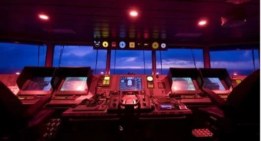
When you’re miles away from home, with sea and stars all around you, one element keeps a vessel on track: navigation. Contemporary merchant vessels are mini-cities at sea. Behind their smooth voyage is a sophisticated network of hi-tech navigational equipment. These devices guarantee safety, efficiency, and precision when sailing across oceans.
Here’s a glance at the best navigational aids employed on merchant navy ships and why they’re so important.
1. Gyro Compass – The Bridge’s North Star
Ditch the old magnetic compass; this one doesn’t depend on the magnetic field of the Earth. A gyro compass indicates true north, immune to metal or electricity interference on board.
It relies on angular momentum and rotation of the Earth to stay oriented. It’s very precise and typically interfaces with autopilot, radar, and ECDIS units.
Why it matters: The gyro is the primary directional reference for the majority of other equipment.
2. Radar (Radio Detection and Ranging) – Your Eyes in the Fog
When the visibility plummets to almost zero because of rain or fog, your best friend is the radar. It will pick up objects, ships, landmasses, and even clouds of rain, and present their distance and bearing on a screen.
Radar equipped with ARPA (Automatic Radar Plotting Aid) also assists in tracking other ships and collision avoidance.
Why it’s important: Radar allows you to “see” when your human eye can’t.
3. ECDIS (Electronic Chart Display and Information System) – The Contemporary Map
There are still paper charts, but the majority of contemporary ships rely on ECDIS, a computerized system for navigation that indicates real-time ship location based on GPS data over electronic nautical charts.
It is capable of automatically plotting routes, indicating dangers, and interfacing with AIS, radar, and weather reporting.
Why it matters: Eliminates human error, updates automatically, and is in many cases mandatory under SOLAS.
4. AIS (Automatic Identification System) – The Sea’s Social Network
Picture all the ships within earshot shouting out their name, speed, direction, and destination. That’s what AIS does. It transmits and receives real-time information from close-by ships and shows it on screen, typically superimposed on radar or ECDIS.
It also assists VTS (Vessel Traffic Services) in tracking marine traffic in congested areas.
Why it matters: Enhances situational awareness and collision avoidance.
5. Magnetic Compass – The Trusty Old-Fashioned Standby
All the tech notwithstanding, SOLAS still insists on a magnetic compass aboard. Why? In case electronics fail. This ancient gadget aligns with Earth’s magnetic field.
Daily checks and adjustments are good seamanship.
Why it matters: Provides a trustworthy standby in the event of electronic system failure.
6. Echo Sounder – Underwater Awareness
The echo sounder measures the depth below the keel using sound waves. A pulse is sent down, and the return time indicates how deep the seabed is. It’s particularly useful in shallow waters and while anchoring.
Some modern systems even show a seabed profile.
Why it matters: Prevents grounding and aids in anchoring operations.
7. GPS (Global Positioning System) – Real-Time Positioning
This one’s simple. GPS receivers installed on board link up with satellites to pinpoint the ship’s precise location anywhere in the world. It gives real-time data on speed, course, and position.
All onboard systems, from ECDIS to logbooks, are more or less dependent on GPS feed.
Why it matters: Delivers precise, real-time navigation information 24/7.
8. BNWAS (Bridge Navigational Watch Alarm System) – The Silent Watchdog
Fatigue is a critical aspect at sea. BNWAS keeps the officer at the watch alert. In case no activity is found, such as button pressing or movement, the system gives alarm signals that increase in number through various levels, even alerting the Captain if needed.
Why it matters: Avoids accidents that are caused due to human lack of attention.
9. Speed Log – Monitoring Speed Through Water
There are two types: Doppler log (measures speed over ground) and impeller log (measures speed through water). Speed logs are essential for voyage planning, ETA calculations, and engine performance analysis.
Why it matters: Important for accurate navigation and monitoring fuel efficiency.
10. Anemometer and Wind Vane – Feeling the Breeze, Scientifically
These instruments determine wind speed and direction. This data is valuable not only for navigation but also for cargo handling and port manoeuvring.
When on tankers or container vessels, knowledge about wind conditions can avoid accidents during loading and unloading.
Why it matters: Facilitates safer deck operations and route planning.
Whether cadet or an experienced officer, it’s essential that you know these tools. They’re not tools, they’re lifelines. The bridge you’re standing on next depends on the silent technology that guides you through the seas safely